Vatnajökull National Park
 Iceland · Europe · Visited 29 September 2025 · Established 2008
I based myself in Höfn, a small fishing town on Iceland's south-east coast, and it turned out to be the perfect spot. The real highlight was the northern lights. We got lucky one evening and caught them from the town, and watching them ripple across the sky with the glacier-capped mountains in the background is something I won't forget in a hurry.
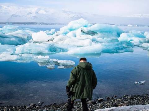
From Höfn, the drive west towards the park takes you past some of Iceland's most dramatic scenery. The first stop, and one I'd recommend making before you even enter the park properly, is Jökulsárlón glacier lagoon. The lagoon only formed in the 1930s as the glacier began retreating, and it has since grown into Iceland's deepest lake. When I was there, enormous chunks of ancient ice were drifting slowly through the water in shades of blue, white, and volcanic black, and if you're really lucky you'll see seals bobbing between them. Across the road, Diamond Beach is where those same icebergs wash ashore onto jet-black sand, scattered like broken glass. It's one of the most photogenic spots I've been to on this entire project.
Walking on the glacier
The centrepiece of the trip was a guided hike on one of the glacier's outlet tongues. Vatnajökull itself is enormous, the largest glacier in Europe by volume, covering about 8% of Iceland's landmass with ice up to 950 metres thick. Walking on it felt surreal. The crevasses, the blue ice, the crunch underfoot, and the sheer emptiness of the place made it feel like being on another planet.
What stayed with me most, though, was how much the glacier has pulled back. Our guide talked us through it, and the numbers are stark: since 2000, the glaciers within the park have lost more than 700 square kilometres of surface area, retreating at an average of 43 square kilometres per year. To put that in context, the entire city of Reykjavík covers 273 square kilometres. Current projections suggest the glaciers could lose half their volume by 2100. You can see it happening. The landscape is littered with moraines and exposed rock that was buried under ice within living memory. If this is on your list, don't sit on it.
Our guide was a character, too. He'd walked the entire length of Iceland, north to south, when he was 18. The kind of person you want showing you around a place like this.
Skaftafell and the park
I visited Skaftafell, which sits right on the edge of the park and is probably the most accessible entry point. It's a well-established hiking area with trails leading to Svartifoss, a waterfall framed by dark basalt columns, and various viewpoints over the glacier and surrounding mountains. It's a good place to explore without needing specialist gear or a guided tour.
Beneath the ice cap sit several active volcanoes, including Grímsvötn, Iceland's most frequently erupting volcano. During my visit, I was told that emergency alerts for local residents go off regularly, warning of potential volcanic activity and glacial flooding. It's the kind of place where you're reminded that the ground beneath you is not as settled as it looks. Fire and ice is not just a tagline here. It's the daily reality.
Why it's worth the visit
Vatnajökull was one of the standout parks of the project so far. The glacier lagoon, the hike on the ice, the northern lights from Höfn, the volcanic alerts crackling in the background. It all added up to something that felt genuinely once-in-a-lifetime, made more urgent by the fact that the glacier is visibly disappearing. What I walked on will not be there for future generations to walk on. That thought alone makes it worth it.