Madeira Natural Park
 Portugal · Europe · Visited 7 October 2025 · Established 1982
Before I get into the park itself, I should explain why I'm counting Madeira. It doesn't hold IUCN Category II national park status, and it's not designated as a national park in the traditional sense. Madeira Natural Park (Parque Natural da Madeira) covers two-thirds of the island and encompasses a mix of conservation zones, farmland, villages, and working agriculture. By the strict "wilderness preservation" definition, it doesn't fit.
But national park designation varies enormously worldwide, and many countries use the term far more loosely than the IUCN Category II definition. The UK is the most obvious example. English and Welsh national parks (the Peak District, the Lake District, Snowdonia) are lived-in, farmed landscapes with villages, roads, and working agriculture throughout. They're closer to IUCN Category V (protected landscape) than Category II. Madeira's mix of conservation zones, farmland, and settlement would fit comfortably within the UK model. The UK explicitly rejected the "wilderness preservation" approach in favour of protecting landscapes shaped by centuries of human use. By that measure, Madeira qualifies, and for a project documenting national parks as broadly defined around the world, I think it deserves its place on the list.
Now, with that out of the way: Madeira is incredible.
The hiking
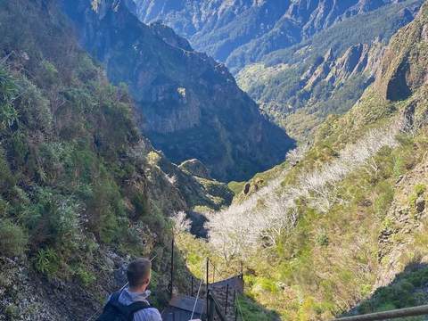
The hiking on Madeira is some of the best I've done anywhere. The island is essentially a volcanic ridge rising sharply out of the Atlantic, and the terrain is dramatic in every direction. The star trails are the levada walks, paths that follow narrow irrigation channels built centuries ago to carry water from the wet north side of the island to the drier south. They wind through tunnels (bring a torch), along cliff edges, behind waterfalls, and deep into the Laurisilva forest, a UNESCO World Heritage Site and one of the last surviving subtropical laurel forests on earth. It's 90% primary growth, some of the trees are estimated to be 800 years old, and walking through it feels genuinely prehistoric.
The 25 Fontes trail is one of the most popular for good reason. It takes you through lush Laurisilva forest to a lagoon fed by 25 small waterfalls pouring down a rock face, and a short detour brings you to the Risco waterfall, the largest on the island, dropping about 100 metres down the mountainside. The whole Rabaçal area is stunning.
For something more exposed and dramatic, the Pico do Arieiro to Pico Ruivo trail is hard to beat. It connects Madeira's third-highest and highest peaks (1,818m and 1,862m respectively), running along a narrow ridge with sheer drops on both sides and views that, on a clear day, stretch to both coasts of the island. Parts of it are carved into the rock face, with tunnels and staircases built into the mountain. It's not technically difficult, but it demands respect, particularly in high winds.
The cloud inversions
The cloud inversions on Madeira are something else entirely. The island's topography creates conditions where thick cloud sits in the valleys while the peaks rise above it into brilliant sunshine. I experienced this driving up to the higher trails: you leave overcast, grey conditions at sea level, pass through the cloud layer, and emerge above it into a completely different world. The valleys below are filled with white cloud like a sea, with the mountain peaks poking through as islands. At sunrise or sunset, the light across the cloud layer is extraordinary. If you get the chance, time your mountain hikes for early morning. The conditions are most common in spring and autumn, but they can happen year-round.
Why it's worth the visit
Madeira doesn't look like a typical national park, and technically it isn't one by the strictest definition. But the Laurisilva forest alone would justify a visit, the hiking is genuinely world-class, and the island's dramatic terrain means you're constantly moving between microclimates, ecosystems, and viewpoints that feel completely different from one another. Add in the cloud inversions, the waterfalls, and the levada trails threading through it all, and it's one of the most rewarding places I've visited on this project. It may not tick every box on the IUCN checklist, but it's earned its spot on my list.